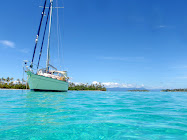
On our way south again. Good. We’re headed to the Dominican Republic. Straight to the DR….not stopping in Mayaguana…not stopping in Turks and Caicos, as originally planned. Maybe we’re moving too fast? We do think of that, but the long wait in Rum Cay sort of tired us out. We want to see new country. Mayaguana and T&C are more of the Bahamas. As a matter of fact T&C used to be part of the Bahamas years ago. We decided instead to go on to the Dominican Republic.
San Clés has decided the same, as noted in my last post.
We peeled out of the Rum Cay marina one by one on a still, quiet morning. Too still...the bugs were eating us alive!
Conch Pearl lead us out, followed by
Kwanesum,
Mschiana and
San Clés. The
Hotel Rum Cay has let us go.
We are anticipating a good trip. We’ve searched the weather window and it called for 4-6 foot seas, winds starting at 12-15kts going down to zero at times. For 3 days or so. The winds we did have are out of the east which is not a good direction but it’s ok. Specially if they aren’t big. They are on our nose, or at best
‘close hauled,’ a sailing term for when sails are trimmed flat for sailing as close to the wind as possible.
‘Close hauled’ is doable but not great. On the nose is stupid bad. Works against you. We put up the main sail as it makes for better riding and any wind that might be to our advantage will pick up in the sail and help us move along. Would be nice at some point if we could strictly sail, but we shall see. We stacked up extra fuel. The direction we’re going doesn’t really play into a good sail. But we’re excited. Excited to leave Rum Cay and get on with our adventure.


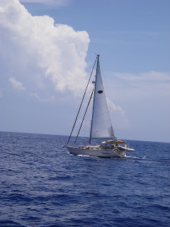
We settle in for the duration. The 4 boats with our sails up… looking good. We chat back and forth on the radio to see how we’re all doing. Should take us about 3 days to get to the DR. I have made sandwiches and hard boiled eggs and other stuff to have on hand…particularly during the night shifts. You don’t want to spend much time down below (
PPM…remember?) (
Proactive Puking Management for those of you just joining us.) We will again do our 3 hours on and 3 hours off routine.

Our destination in the Dominican Republic is Luperón, on the north side of the island. It’s considered
a“hurricane hole.” We had several options of where to spend Hurricane Season, which our insurance company defines as July 1 – November 1. The insurance companies give parameters for the zone you should be inside during this time in order to remain covered. Our insurance company defines the ‘zone’ as between the Savannah River to the southern coast of Grenada. [add latitudes here] So a decision needed to be made. At the time, when making this decision, we were in Nassau, with the beginning of May being our departure date south, depending as always on the weather. Do we go back to, say, Charleston, SC, which we loved, and then redo the miles we had already traveled? Do we head quickly down to Grenada? This would hurry our trip and determine it to be a little less relaxing. Should we head through the Gulf and straight for Panama? We would miss the Caribbean entirely but get to the west coast sooner. Should we keep on course, head down the Exumas and over to the
“hurricane hole” in the Dominican Republic? The
“hurricane hole”, or Luperón, would not be sanctioned by our insurance company. We could, if we spent more money, get a rider, but it had a huge deductible.
So what do we do? This is our home. We must make a good decision. We decide to email our weather guru, Chris Parker, and give him our options and see what he thinks. If you remember from my previous posts, Chris Parker is the expert on weather in the Bahamas and Caribbean and beyond. We have hired his services for the duration of our trip. Each day we get an email of weather from him and if we’re making a crossing or a long voyage we will contact him on the SSB radio and get his opinion on a weather window. We feel it is a good investment of our dollars. Chris immediately emailed us back and gave his opinion on our options:
- Going back to Charleston? – That would be back tracking which doesn't really suit us. Chris said: You're also more likely to get a Hurricane there. With an April or May departure, there's no reason you couldn't be somewhere secure by July 1 (Luperón, the ABCs, Trinidad, Venezuela, Colombia, Panama, the RioDulce).
- Heading quickly to southern Grenada? - Would this even be feasible from Nassau? Chris said: yes, but not until late May or June do ColdFRONTs stop, making it tougher to get to the E Caribbean. We asked additionally…what route should we take if we did that? Chris said: it depends on the weather pattern in place when you're ready to go. If you want to enjoy the Bahamas, hop down the chain...but they you'll be more pressed for time in the Caribbean. If you want more time in the Caribbean & don't mind a longer offshore passage, go E or ENE from Nassau (or anywhere in the Bahamas), then make a gradual turn SE-S as you get far-enough East to lay the E Caribbean in the Trades.
- Heading straight to the Gulf and the Panama Canal? - BUT we would miss the Caribbean, DR and PR included, which would be a shame. And Chris agreed: Yes, a shame. No need to miss areas to the East.
- Heading to the Hurricane Hole in the DR? - Our insurance would not cover that if we get damage from a named storm, but they say there are good “hurricane holes” there. It might be nerve wracking. Chris’s response: Given the orientation of the Dominican Republic, the only way you could get a significant Hurricane in the Luperón area is from a SW-moving Hurricane (approaching from the NE), or from a Hurricane paralleling the DR's N Coast. While neither is impossible, both are highly unlikely. Plus, I believe there are reasonable "hurricane holes", though there's no such thing as a perfect "hurricane hole."
Obviously we made the decision. And it didn’t take us long. Let’s keep going. Let’s go to the DR and wait. And we’re on our way…pounding against the wind and the seas but happy as clams to be heading the right direction. We’re betting on the
‘Come Line.’ Kinda.
On we plod, pounding on the seas. We thought we’d have smoother sailing. We actually did have one great morning along the way. Woke up to nice, calm seas…coffee in the cockpit. I loved it. Wish it could be like all the way…wind at our back…sailing. Oh well…once we get down into the Virgins we can get the wind in a more favorable direction. Can’t wait.
We pass into the Tropics.

The Tropic of Cancer, according to Wikipedia:
one of five major degree measures or major circles of latitude that mark maps of the Earth. It is the northernmost latitude at which the Sun can appear directly overhead at noon. This event occurs at the June solstice, when the northern hemisphere is tilted towards the sun to its maximum extent. The Tropic of Cancer currently lies 23° 26′ 22″ north of the equator. North of this latitude are the subtropics and Northern Temperate Zone. The equivalent line of latitude south of the equator is called the Tropic of Capricorn, and the region between the two, centered on the equator, is known as the tropics.Kind of thrilling, passing into the tropics. Randy is down below sleeping, so I take a picture of the chart plotter passing the latitude mark. I notice something out of the corner of my eye. Something jumping in the water. Shoot I missed it! Wait…there it goes again!
I have my camera in my hand so I get ready, in case it jumps again. Holy cow! It’s big! It looks kinda like a dolphin but it’s not graceful like a dolphin. It’s very clumsy. Like a whale, but smaller like a dolphin. I get some good pictures. I still have no clue what this odd thing is that’s jumping in the water, but I’m so glad I had my camera in my hand. Later when I have time I’ll zoom in on it and try to figure out what it is. In the meantime, we continue…into the Tropics. (Turns out, it was a Bottle Nose Whale.)


Gets
‘hairy’ at night. Lots of lightening going on…in the distance, but at night it looks very menacing. Some people don’t like to sail at night. It doesn’t bother Randy and me. As long as we stay vigilant, watch for ships. As a matter of fact one night along the way I was concerned about a ship I saw…heading across our path. Even though I had it on the AIS (Automatic Information System) and it told me we were plenty far away, it looked like it was going to cross right in front of us!
“Uhhh, Randy…can you come up here for a minute?” I wanted him to validate that we were far enough away. And as the ship got closer it looked like it was right in front of
San Clés! That’s the weird part about night time. Things look closer than they actually are! We were fine, we were plenty far away, as the AIS said. And
San Clés was, too. But better safe than sorry I say!
To divert here a minute I’ll explain the AIS. Not sure that I’ve done that before. It’s part of our chart plotter system and it’s very cool. It picks up any ships that are in the area and puts them on the chart plotter. They show up as a little triangle. By clicking on the little triangle you will get all the information about that particular ship. How big it is, what the name of the ship is, where’s it’s coming from, where it’s going, what it’s carrying, the closest point of approach…all the information you need to avoid it. Very cool and it wasn’t that expensive. It’s almost better than radar sometimes. We are very glad to have it onboard. And it’s interesting to use.
As we carry on the first night, we actually all changed course to try to avoid an oncoming squall. It seemed to work. As we stand now,
San Clés is leading us…by far the fastest boat. We are next and
Mschiana and
Conch Pearl are behind us. We want to stay with
San Clés as we’re heading to the same destination.
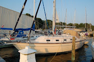
San Clés, a Passport 43 with a fin keel, is hard to keep up with so we really push
Kwanesum hard. We are motor-sailing and averaging about 5 knots, sometimes faster, sometimes slower. We want to make sure we arrive at our destination in the day light. Timing is important. Our rule, and one that is advised and used by most cruisers, is never to go into a new anchorage or marina at night. This is a general rule of sorts that cruisers follow, but there are some that dare to do it. If you are familiar with the anchorage or entrance to a harbor it is not as disconcerting. But we are not familiar with any of this so we must reach our destination before dark or stay outside until morning.
Next morning is the calm and wonderful morning I mentioned before. We are near Mayaguana and this is when we will part from
Mschiana and
Conch Pearl. Kinda sad! But we will catch up with them on down the road in the DR, PR or VI. We bid each other
fair winds and promise to meet up later and stay in touch via email.
We have now changed our exact destination to enter the Dominican Republic. Instead of going into Luperón first, and checking into the country there,
San Clés and
Kwanesum will go into Ocean World Marina at Puerto Plata and check in there. We both researched it and decided this would be easiest. It’s easy to get into the marina, we can check into the country, refuel, reprovision, do laundry, fill with water…and relax after our long trip. Sounds good. That’s what we’ll do. Then
Kwanesum will go on to Luperón for the season and
San Clés will head to Puerto Rico.
San Clés’ destination will be St John in the US Virgins where they will celebrate their anniversary.
So...on we go. Day three. Are we there yet? We’re getting anxious to get to our destination. Sandwiches are about gone. Boiled eggs are gone. 3rd day of wearing same clothes and no shower (it’s just easier that way.) It’s kind of hazy today…the seas are still big. Give us a break! Ugh. I think I spot some hills but I’m not sure. Hard to see through the haze. But I’m pretty sure I see hills. There are NO hills throughout the Bahamas and T & C. They say you can smell the DR when you get close. Smell the earth. My smeller’s not that good. But I’m testing it none the less. We’re now starting to worry about our fuel. We calculated we had plenty, but didn’t expect the seas to hold us back so much. We figure we use a little more than a gallon an hour. Our tank holds 75 gallons. And we carried an extra 10 gallons. We’ve already poured the extra in. Let’s see how we do.
Now we can see the hills. Hooray! Beautiful, green hills. It’s still pretty hazy but we can see them none the less. We aren’t far off now. But sometimes that last bit, when you know you’re almost there, takes forever! We radio
San Clés and they informed us they alerted Ocean World that we’re on our way in. Cool. As we’re plodding along a fancy, schmancy power yacht zooms by, bouncing wildly on the water.
“Oh yeah??!! What else’d you get for Christmas??!!!” We had boat envy at that time. Speed envy.
“Show offs!!!”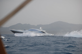
We watch
San Clés make their turn to approach to the entrance. We hail
San Clés again.
“Lyman, we’re coming in on fumes. Just want to let you know we may need assistance.” Our gauge registers…very…low. OK,
Kwanesum…get us there.
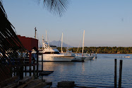
“She’ll get us there, Ran. She always does.” I’m at the helm and we make the turn at the yellow marker to head our way inside. Tired, excited, kinda smelly and ready to stop, we bounce our way in. It’s a straight shot in once you turn, but the seas are still very, very bouncy. Makes it a bit of a challenge to keep the boat straight. I’m on the helm and on the radio with the harbor master finding out where to go.
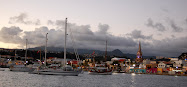
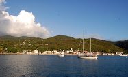
“Make a port turn just after you enter and head to the back F docks.” “Roger that.” I make that left turn and it’s nice…so nice…and …calm…hooray!!! What a nice marina! Cement docks…lots of room. We decide to get fuel later as we’re exhausted and it’s already getting close to 6pm.
I find the spot they want us…F Dock…I pull
Kwanesum right in. F12…our spot is F12. We tie up…there are many hands helping…we are so excited! So glad to be here. We have our DR flag up and our yellow quarantine flag. A golf cart is here to take Lyman and Randy to immigration. To their delight…the immigration person was a very, lovely Dominicana. Yeah, yeah, yeah…. Back to the boat…time for cocktails! We are so tired we just go down to
San Clés with our wine and beer in hand and toast while sitting on the dock.
“To our landing in the Dominican Republic!” “Cheers!”
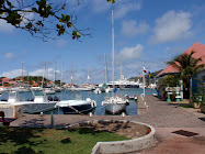
Now we settle in. The first few days we sleep, clean, and sleep again. Do laundry and provision. We provisioned at La Serena, a big store in Puerto Plata, kinda like a Wal Mart. As a matter of fact, Wal Mart owns it or is buying it, I think. Obviously we rented a car.
San Clés will not be here long so we decide to share the rent of a car and go exploring. So, first, we provisioned.
“Let’s do the Falls,” Terri said. The Falls…the Falls…I read somewhere about the Falls, but I need to refresh my memory.
“The 27 Charcos! It will be fun!” OK! I’m up for anything. I look it up on the internet and it looks really fun. Wonder how hard it is? Oh well…I can handle it.
“You hike up the Falls and then slide or jump on the way down.” OK.
“We will just do 12…not the whole 27.” OK.
Off we go. First we need to find our way there. Driving in the DR is not easy. There don’t seem to be many rules…there are a LOT of cars and even MORE motorcycles or scooters and not many rules. Or at least not many that are followed. They do drive on the same side of the road. That's helpful. There’s a great deal of faith put into the
“other guy.” We head to the Falls full of anticipation. Get there…put our swim suits on…have our Teva sandals on. Now, what do we do? We need helmets and life jackets. OK. We acquire our guide, who brings along a helper. OK. Let’s get going. We have to hike for awhile to get to the falls…across a fun, rope bridge, through streams.
“Come on Momma.” They called me
‘Momma’ and made sure I had sure footing crossing the streams, holding my hand. I appreciated that.


This was sooo fun! It was a beautiful, warm day. The area was gorgeous. The falls were magnificent. You had to fight against the current a few times to go up the Falls, and …you had to climb some pretty
‘hairy’ spots. And …you had to hold on to ropes to pull yourself up against the rush, rushing water. Climbing up to the 7th fall was the worst. Well…the one where we had to climb a precarious wall was kinda hard, too, but up that 7th fall was definitely the most challenging. The guides had to PULL us up. Not easy. They are very strong however. And were able to pull up this plus-sized
‘momma.’ We still had more to go. I decided not to go further. The 8th fall we had to climb was REALLY challenging. You had to act like a monkey to get up it while holding on a rope…against the current. I don’t want to push my luck. Randy decides to stay with me. Terri and Lyman go on up to the 12th fall while we waited. (They’re younger. =) ) It was still hard for them to get up. But they did it and went to the 12th one. They said we really didn’t miss much by not going that distance. The other falls weren’t any more fun that what we’ve already done. Good.
So now…down we go! Cool! We start jumping…very, very high some of them were…and sliding our way down. Really fun but a little precarious, now and then. Coming down was definitely faster and easier than going up! There was one fall…pretty tall. I look down. Well…gotta get down somehow!
Kowabunga!! So fun. Great, great, great day. We end the trip with beer and great food at their little restaurant there. This experience was one of the highlights of my life, I tell ya.
Next day…we still have a car…agenda: the top of the mountain and Luperón. Remember Luperón is where we want to end up for the season. First we tried to find our way to Mount Isabel de Torres, a scientific reserve and a peaceful botanical garden. They have a
teleferico (gondola) that takes you up but we decided to drive. I’m glad as you see more country and people that way.
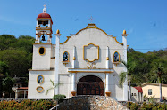
Mt Isabel de Torres is 2600ft up and it’s gorgeous. We had a wonderful clear morning and the views were spectacular. There is also a wonderful large statue of Christ similar to the one in Rio de Janeiro. Awesome.


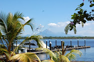
Now we drive on to check out Luperón and see if we can find our friends on
GravyBoat,
Opal and
Wanderlust there. It's a wonderful drive through the countryside to get there. Luperón is a small, little sleepy town northwest of Puerto Plata. Found the City Dock and we hailed our friends
GravyBoat on the radio to let them know we were in town. They were at anchor there. They dinghyed in…so fun to see them. We hadn't seen them or Marc on
Opal since Nassau. Lots of boats anchored here. We went to Capt Steves for a beer, where we ran into other fellow cruisers we have met along the way. Marc from s/v
Opal and the Duncans off of s/v
Wanderlust. Fun place…fun to see everyone.
Back to our home away from home. Ocean World. Terry and Lyman (
San Clés) are waiting for a weather window to cross the Mona Passage to Puerto Rico. They aren’t getting one. They decide to stay. We decide to stay. We like it here. Wonderful people, a pool to use at any time, fresh water delivered, ice delivered, laundry done for you, electricity if we need it, guards 24 hours, restaurants close by, mini-mercados close by…nice. We all go up to talk to James, the marina manager to see what kind of deal he can give us if we stay for whole season. It’s a go! James gave us a great price on slip fees, electricity and water for the 6 months. Excellent. We will stay here for hurricane season. Now … to the pool with our adult beverages! Ahhhhh….


 Time out. I traveled to CA for month to spend time with the kids and grandkids. Randy stayed with the boat. Since it is hurricane season we didn’t feel comfortable leaving Kwanesum by herself. First season we’ve weathered in the hurricane zone. So far so good, but we have 8 more weeks and September is notoriously busy with storms. And there's one sitting out there now that we're watching. We shall see if we made the right decision to stick it out here…in the